Sea level change is much on our minds today because of the threat of global warming. Yet, the changes we face in the coming centuries are as nothing compared with those that occurred in the past. The melting of ice following the end of the last Ice Age led to a 130m sea level rise reaching present-day levels 6000 years ago, drowning almost half of the present European landmass previously exposed by low sea levels. These territories were primary areas for human settlement, and can provide unique archaeological and environmental data on key transformations in human social evolution such as the development of seafaring, fishing and coastal migration, on past sea-level and climate change, and the impact of these often-dramatic changes on human societies.
COST Action TD0902 SPLASHCOS (Submerged Prehistoric Archaeology and Landscapes of the Continental Shelf) has focused specifically on this subject, bringing together more than 100 archaeologists, marine geoscientists, palaeoclimatologists, cultural heritage managers and representatives of industrial companies from 25 European states. As part of its activities, the Action has fostered the establishment of a pan-European digital mapping of underwater sites, enabling a more detailed understanding of the archaeological data preserved on the seabed.
In this context, a group of researchers participating in the Action, associated with the Dutch Cultural Heritage Agency (RCE), developed an important collaboration with the Port of Rotterdam Authority (PoR), and with geoscientists and archaeologists from the Rotterdam Archaeological Research Office (BOOR) and the Deltares Research Institute, to investigate submerged evidence of life in the Ice Age present in areas in and around the Port of Rotterdam.
The large quantities of bones from ice-age mammals and occasional stone artefacts caught up in the nets of trawler fishermen have long proven the presence of drowned prehistoric archaeology on the North Sea floor. SPLASHCOS has highlighted the importance of these discoveries as clues to the systematic investigation of drowned landscapes. The PoR’s announced plans for the construction of the new Maasvlakte 2 harbour, requiring the dredging of 240 million cubic metres of sediment to a depth of 20m, drew attention to the valuable archaeological evidence at risk. Thanks to early discussions, the RCE worked with the PoR and the BOOR to ensure that research was conducted without impeding the progress of construction work. A working group was set up comprising archaeologists, engineers, decision makers, and Quaternary geologists, and the PoR allocated a reserve of €3 million for research.
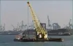
A step-wise approach first used geological data and acoustic survey to identify features of the drowned landscape such as ancient shorelines, river deltas and sand dunes, which might have archaeological remains. Drilling sediment cores in target areas revealed a site of the Mesolithic period (a period of the Stone Age dated to 12,000 to 6000 years ago) underneath one of the harbour floors that would be destroyed by dredging. Innovative technical solutions were devised to excavate relatively large volumes of sediment to rescue some of the archaeological data. A pontoon and crane were adapted to scrape bulk samples of sediment in 20cm slices from the harbour floor, and industrial-scale sieves were constructed to help in the sorting of the sediment for stone tools, animal bones and other environmental data.
Remnants of Mesolithic sites were discovered in three locations at a depth of 17-21m radiocarbon-dated to 9500 years ago. The excellent preservation under water resulted in finds of bone, charcoal, wood, and plant material as well as stone artefacts, providing unusually detailed evidence of environment and early Mesolithic palaeoeoconomy.
The findings are an ideal example of what can be achieved if heritage managers and scientists engage with industrial companies at an early stage in construction work. COST Action SPLASHCOS has proved instrumental in promoting this kind of collaboration: not only highlighting good practices in the sustainable management of the submerged landscape such as the example described above, but also setting up common standards for seabed mapping. Professor Geoff Bailey, Chair of the SPLASHCOS Action, said: “COST provides an ideal framework for developing and promoting collaborative solutions for the research and management of valuable underwater archives relating to European prehistory and the nature of past sea level change and its human impact, and this is of vital importance as the commercial and industrial exploitation of the continental shelf intensifies.”